Before any control: finding out what is there
You know your country better than anyone. We start by asking what you have noticed: where the rootings are, which paddocks are losing lambs, where deer are hitting fences and when activity seems to change. Before arriving, we review aerial imagery and property maps to find likely harbour, water and travel corridors.
We then walk and drive the property in a systematic way, reading the signs on the ground rather than relying on a quick look from the ute. We record evidence such as:
- Tracks and pads on soft ground, creek banks, dam edges and dusty tracks, including the likely species and how recent the movement appears.
- Scats and droppings that indicate which species are using particular parts of the property.
- Damage such as pig rootings, deer rubs on trees, stock losses in lambing paddocks and warrens undermining a dam wall.
- Hair catches and rub marks on wire, posts and trees.
- Feeding evidence including chewed crops, grazed pasture, raided grain storage and lost stock.
- Water, cover and access, including where animals drink, where they lie up and which areas can be worked safely.
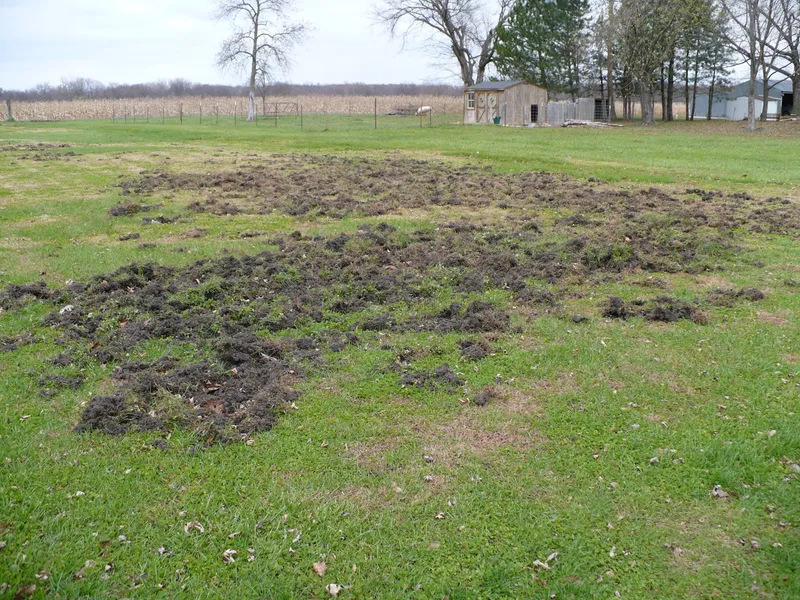
Each observation is GPS recorded and plotted on your property map. That turns separate marks on the ground into a useful picture, such as a corridor between the creek and ridge, a shared feeding area or a gap where animals are entering from adjoining country.
Landholders often ask, “How many are there?” A roaming population cannot be counted exactly. We estimate activity using sign density, trail camera detections and, when flown, a thermal drone count. Each species is rated low, moderate, high or severe, with an explanation of what that level means for your operation. Any count includes our confidence in it. An honest estimate is more useful than a precise-sounding number that cannot be supported.
Thermal surveys and trail cameras
Thermal drones detect body heat, which can help locate pigs and deer in scrub, long grass and darkness. A single session can cover hundreds of acres. Flights are carried out at dawn, dusk or night, when the temperature difference between animals and the surrounding ground is strongest. Each detection is GPS tagged and added to the property map. More detail is available on our thermal drone survey service.
A thermal survey can earn its cost when a baseline count is needed before a programme, particularly for pigs and deer. After control work, a follow-up flight may show whether the count has changed and where remaining animals are located.
It is not the right tool for every job. Rabbits are too small to count reliably from altitude. Dense, closed canopy can block heat signatures, while temperatures above about 30 degrees Celsius reduce contrast. Wind, rain and fog can also degrade the images. We discuss these limits before committing your property to a flight.
Trail cameras provide a different view. We place them at choke points such as creek crossings, fence gaps, gates and established pads, following NSW DPI guidance. During an assessment they are generally left in place for one to two weeks. Where Telstra 4G coverage is available, cellular cameras can send photographs as activity occurs. Elsewhere, offline cameras record to cards that are collected later.
A drone survey is a snapshot of one night. Cameras show what happens across days and weeks: which species are present, when they move, how many travel together and whether the image shows a wild dog or a large fox. Many images are empty triggers caused by wind or shadow, so AI species identification is used to filter them and classify animal detections into structured data.
Our guide to thermal drone surveys compared with trail cameras explains the trade-offs. We also explain how trail cameras and AI support pest monitoring.
Choosing the method
The method needs to suit the species, the country and what is nearby. We do not start with a preferred method and try to make the property fit it. The main options are:
- Ground shooting, which is targeted, immediate and selective around houses, sheds, water points or other animals. It is the main control tool for deer because there are no registered toxins for deer in NSW.
- Baiting, which can support landscape-scale reduction beyond the area covered by shooting. It works best when neighbouring properties and LLS programmes are coordinated.
- Trapping, which can suit areas near dwellings, working dogs or dense scrub, as well as animals that avoid baits or spotlights. A corral trap can take a whole pig mob at one time.
Most programmes use a combination. As an illustrative example, consider a grazing property with pigs using two creek lines and working dogs near the house. The back creek, away from the dogs, may suit baiting. A feeding site closer to the house may suit a corral trap. Thermal ground shooting may then address pigs that avoided both. This is an illustrative example only.
Timing also matters. Fox work can be planned before lambing, wild dog work through late winter and spring and pig work when dry conditions bring them closer to water. The process begins with a property pest assessment, so the plan reflects the evidence on your place.
Measuring whether it worked
A result only means something when it can be compared with a starting point. The baseline records the estimated level for each species, camera detection rates at fixed sites, a thermal count when a survey is flown and the location and severity of damage identified at the start.
After control, we repeat the same measures at the same sites and across the same survey area, under similar conditions where possible. This allows a like-for-like comparison. Are detections at the creek crossing lower? Is the follow-up count lower, and where are the remaining animals? Has fresh rooting stopped in the mapped areas? For ongoing programmes, we track the trend over seasons and adjust the approach as the evidence changes.
A tally of animals removed is not enough on its own. It records what was removed, not what remains. Fifteen pigs removed from a population estimated at twenty means something very different from fifteen removed from an estimated eighty. A high tally may also reflect increasing pressure or movement from adjoining properties.
For that reason, the number removed is reported beside the before and after picture. The evidence can support discussions with a business partner, grant body or when setting a pest management budget.
What your report contains
Your written report brings the field records, mapped evidence and next steps together in one place. Depending on the work completed, it includes:
- Species identified and the evidence supporting each identification.
- Estimated activity level for each species, rated low, moderate, high or severe, with confidence stated.
- Damage by type and severity, supported by photographs and GPS locations.
- A GPS map showing where we worked and where activity was detected.
- Trail camera results covering species, detections, times and locations.
- Thermal survey stills and an annotated detection map when a flight was completed.
- Animals removed by species and the areas covered.
- For baiting, GPS-mapped bait stations, bait take and retrieval records.
- For trapping, trap locations, captures and any non-target events.
- Field observations and priority risk areas.
- Recommended next steps, method, timing and coordination with neighbours or LLS.
- Monitoring recommendations, including what to watch and when to follow up.
The report belongs to you. You can keep it for your own records, use it for planning or provide it to another service provider.
Limits of what we can measure
Monitoring provides evidence, but it also has limits. We state these at the start and include them in the agreed scope, rather than raising them after the work:
- Counts are estimates. Thermal surveys may miss animals beneath dense canopy, in hot conditions or animals too small to detect reliably from altitude. Cameras only record what passes within their view.
- One visit is a snapshot. Animals can move within a property or cross between neighbouring properties before, during and after the work.
- No outcome is promised. Results depend on pest pressure, terrain, weather and activity on surrounding land.
- A report covers only the areas worked and the period covered by the agreed programme.
Survey conditions, coverage and confidence levels explain how the evidence should be read without suggesting that a roaming population is fixed or completely visible.
How we handle your property information
Maps, GPS records, camera images and reports are used only for pest control work on your property.
- Who sees it: the landholder and our operators, where access is needed to carry out the work safely. Information is shared with insurers or regulators only where coverage or the law requires it. It is never sold.
- Storage: records are stored securely, with access limited to authorised personnel.
- Retention: information is kept for the working relationship plus 12 months, then archived or deleted.
- Your rights: you can ask to see, correct, export or delete your property information.
- Drone imagery: surveys look for animals. Images of people, dwellings or private activities are not recorded or retained.
- Publishing: maps, images or details that could identify a client’s property are never published without the client’s written consent.
Our privacy information explains how property records are handled. Monitoring and reporting can also help document the reasonable steps taken as part of a landholder’s responsibilities. Our guide to biosecurity duty and reasonable steps in NSW provides further context.